Page: 351 deg Bearing Angle. Posted September 5, 2011
Several Fine Examples
I look at the Biographies and maps of most of the ham radio operators who visit my blog on qrz.com. I would look up those that go to my http://w7buf.com website too, but I do not have a way to get their call signs. Today I looked up qrz visitor YO3DEX, Victor Ursu. The map on his details page showed a nearly perfect horizontal line connecting his location to mine. I thought to myself that he must have about the same latitude as me. Indeed he does. My latitude is 44.1 deg North and his latitude is 44.4 North. But he is in Romania, across an entire Ocean from me, 6000 miles away, so the Great Circle connecting us gives a bearing angle of 21.3 degrees from me. Wow, I am up here at 44 degrees North and that bearing angle that is 21 degrees East of NORTH!! That means the Great Circle connecting us has a pretty steep inclination relative to the equator. Very nice!
But the very next blog visitor I looked up had even more interesting numbers!
It was UN7ZL, Vladimir Gleizer. What caught my eye right on the map at QRZ was that he is West of me. I am on the West Coast of the USA, 60 miles from the Pacific Ocean. Most of my blog visitors are from the States with a pretty sizable fraction from Western Europe. But his being West of me is a small thing compared to what else I found.
I then saw he is from Kazakhstan, but I had NO idea where in the world that might be! Turns out it is West of Mongolia and quite a way North of Afghanistan and Pakistan. NorthEast of Turkey. (Looking up radio operators is teaching me things I never learned about the Geographic locations of other countries). But is Vladimir really West of me? West?
Next I looked at his longitude. Mine is -123 degrees (West). His is +71 degrees (East). Going East from me, I would have to go 194 degrees around the Earth to reach him. That is a little more than 180, which explains why qrz shows him being to my West instead of East. It is a shorter distance going West, though still about 6000 miles. The Earth's circumference is around 24,000 miles, so a first naive thought might be to expect someone nearly 180 degrees longitude away, to be around 12,000 miles away. But no, that would be ignoring a couple of things. For one thing we are not both at the Equator, nor are we equal angles on opposite sides of the Equator. The other thing is that the shortest distance connecting two locations on the surface of the Earth is along a Great Circle, not a straight line on a Mercator (flat projection) map.
Yes, since he is nearly 180 degrees longitude from me, and we are both in the Northern Hemisphere, the Great Circle connecting us must run almost through the North Pole!! Sure enough, I took a look at his bearing angle!
His bearing angle is 351.3 Degrees!
Now THAT is an interesting bearing angle! I LOVE that! Take a look at this neat map plotted courtesy of http://www.gcmap.com
At first glance it seems like the red arc is running East of North from my Oregon location, but Vancouver Canada is due North of me and that red arc passes West of Vancouver, so it has a bearing angle less than 360.
Well, if someone having the same latitude as me does not have a bearing angle of 90 degrees, who WOULD have that bearing angle?
I will only see a bearing angle of 90 degrees if my latitude is the same as the inclination angle between the Equator and the Great Circle connection me and the other location. That prize (so far) goes to K9MRD Wayne L Smith near Omaha Nebraska. He happened to visit my blog just before these other two fellows. Wayne has a bearing angle of 88.7 degrees from me. That means I am at the point on the Great Circle where it goes no Further North. It also means that the ascending node, (the place where that Great Circle crosses the Equator as it entersg the Northern Hemisphere) will be 90 degrees West of my longitude. Can you see why? The Equator crossing point has to be 90 degrees from the place where the Great Circle reaches the maximum Northerly value. These two conclusions may not be obvious. There are familiar to me because I have studied orbits a great deal. Inclination and longitudes of ascending nodes are two of the six parameters that fully define an orbit. It is best to try to visualize these things in 3D, as though viewing the Earth from out in space, although drawing circles on an Orange works pretty well too.
I am at 123 degrees West Longitude, so the Ascending node will be 90 degrees further West, at longitude 123 + 90 = 213 degrees West. Oops! That is more than 180 so it will be expressed as an EASTERN Longitude instead. It is 213-180 = 33 degrees beyond 180 in a Westerly sense so it will be 33 degrees SHORT of 180 in an Easterly sense. The longitude of the ascending node will be 147 East. That turns out to be just a bit North of Papua New Guinea.
Here is a Great Circle plot showing from the ascending node near Papua New Guinea to my location, where the red line is parallel to a latitude line, and then on to K9MRD in Omaha Nebraska. 
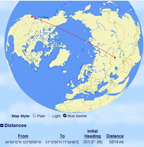
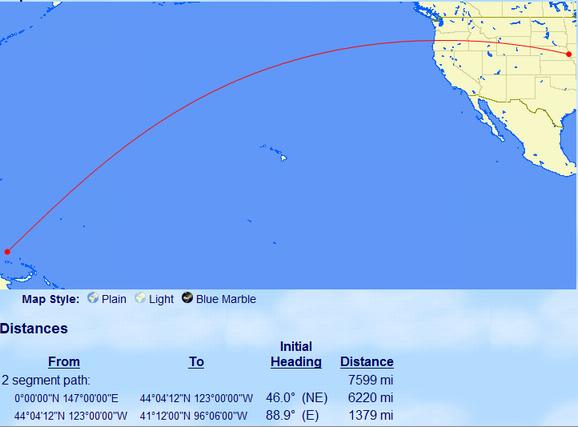
Everything on the Western shores of the Pacific (North of the Equator) has an EASTERN longitude!
I do not know why it always surprises me so much that everything on the Western shores of the Pacific (North of the Equator) has an EASTERN longitude. It does not SEEM far enough away from me to have an EASTERN longitude! I suppose it is because I do not fully realize what it means that I am at 123 degrees West. I am already two thirds of the way from the Greenwich Meridian to the International Date Line. The Date line is only another 60 degrees West of me. But what also contributes to my being surprised so often is that the Pacific Ocean is about 85 degrees longitude wide from Western North America to Japan. That means that just to get to the the Western shores of the Pacific Ocean takes me beyond the 180 degrees West longitude Meridian. Nealy all the land on the Western shores of the Pacific Ocean have East Longitudes. That still seems odd to me.
But going back to the width of the Pacific, the last time I checked 90 degrees is about one fourth of the way around a circle, so the Pacific Ocean spans almost one quarter of the circumference of the Earth. I am sure the astronauts who orbit the Earth get a good sense of the size of that Ocean every time it takes them some 23 minutes to fly over the full width of it. They fly in an orbit inclined about 55 degrees to the Equator though, so they take an even longer path when flying over it from Australia to North America.
This image gives you some idea how expansive the Pacific Ocean really is.
Comments on anything at this website?
Please go to the COMMENTS page using the link further down this page.
After submitting your comment there,
find and click on the link on that page which enables you to return to the main page.