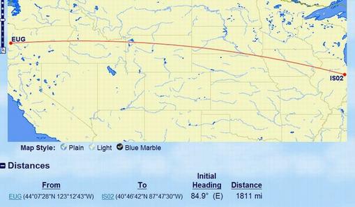
While looking at the map I made of Ham operators I have heard, I noticed that some of the bearing angles reported by QRZ don’t seem to be what I would expect. For example, I would think that a location East of me, with a SMALLER/LOWER latitude, would show a bearing angle of MORE than 90 degrees. First I noticed that W7WTR in Idaho Falls, showed a bearing angle of 90.0 degrees in QRZ. Then I noticed his latitude is SMALLER/LOWER than mine at 43.545718, compared to my 44.077080. (His longitude is smaller in a Westerly sense, making him East of me; his -112.051715 to my -123.085120, so no problem there). But why isn’t his bearing angle at least a little bit greater than 90.0? His latitude is about half a degree smaller at a distance of 550 miles. Roughly how many miles is half a degree latitude? A ham 100 miles almost due North of me has latitude 45.505. That means that about 100 miles corresponds roughly with 1.4 degrees of latitude. Idaho Falls is 0.52 degrees smaller latitude, so that would translate to about W7WTR being about 33 miles South while 550 miles East. Using trigonometry, I would expect this to be about 3 degrees deviation South of East. On a flat Earth, there is no way that the bearing angle would be 90.0 degrees, it would be about 93 degrees. That suggests that this seeming anomaly has to do with bearing angles measured along “Great Circle” arcs rather than being angles calculated using flat out plane Geometry and Trigonometry.
A second example showed up with WB9Z in Indianna. His latitude is 40.717782, compared to my 44.077080 . He is both East of me and South of me, yet his bearing angle in QRZ is 85.0 degrees, not greater than 90. When I first started thinking about these apparent anomalies, I thought maybe it was because the bearing angle was being measured from MAGNETIC North, instead of from a North South running line of Longitude. So I checked a few locations almost due North and due South of me and they have bearing angles around 3 or 4 degrees from 0 or 180 and therefore seem to be measured relative to a N-S longitude line. In Portland, Oregon, (100 Miles North of me) a compass points 16 degrees east of True North, so if bearing angles were referenced to magnetic North, the “anomalies” I have been talking about would be on the order of 16 degrees, not just a few degrees.
So then, I guess it comes down to Great Circles. A circle made by locations having equal latitude is not a Great Circle – except at the Equator. A Great Circle lies in a plane which has the center of the Earth as the center of the circle. Taking an extreme example, for a location at my latitude but 180 degrees different longitude, i.e.; probably in Russia someplace, the Great Circle connecting these two points would run right across the North Pole. The bearing angle in that case would be 0.00!!! It just will not do, to argue that since this location is neither North nor South of mine according to latitude, the bearing angle should be 90 or 270 degrees. Using the Great Circle mapping capabilities available at (which is intended for airline flight path estimates), I got a Great Circle map from my location to a place very very near to WB9Z in Indianna. His bearing angle in QRZ was given as 85.0 degrees, less than 90 even though his latitude is South of mine. In this map, you can easily see that the initial “trajectory” of the Great Circle from my location, is less than 90 degrees. I’m assuming that apparent “trajectory” angle is what is being reported as “bearing angle.” MYSTERY SOLVED!!!!!!

Initial "trajectory" from Oregon is less than 90 degrees on this Great Circle to Indianna
1 ping
Wednesday says:
September 19, 2011 at 4:40 pm (UTC -7)
I love reading these articles because they’re short but informative.